by Ian Kluft
Introduction
Portland International Airport (PDX) may not be the biggest and doesn't have the most of any airlines or types of aircraft. But for planespotters and aviation geeks (or "avgeeks"), we enjoy a fantastic variety here.
Being located in the Pacific Northwest (PNW) invites comparison to Seattle-Tacoma International Airport (SEA) and the Seattle area. Though Seattle is bigger and has more airlines and two Boeing factories, their airports are all specialized and don't have the same variety for planespotting within a single airport.
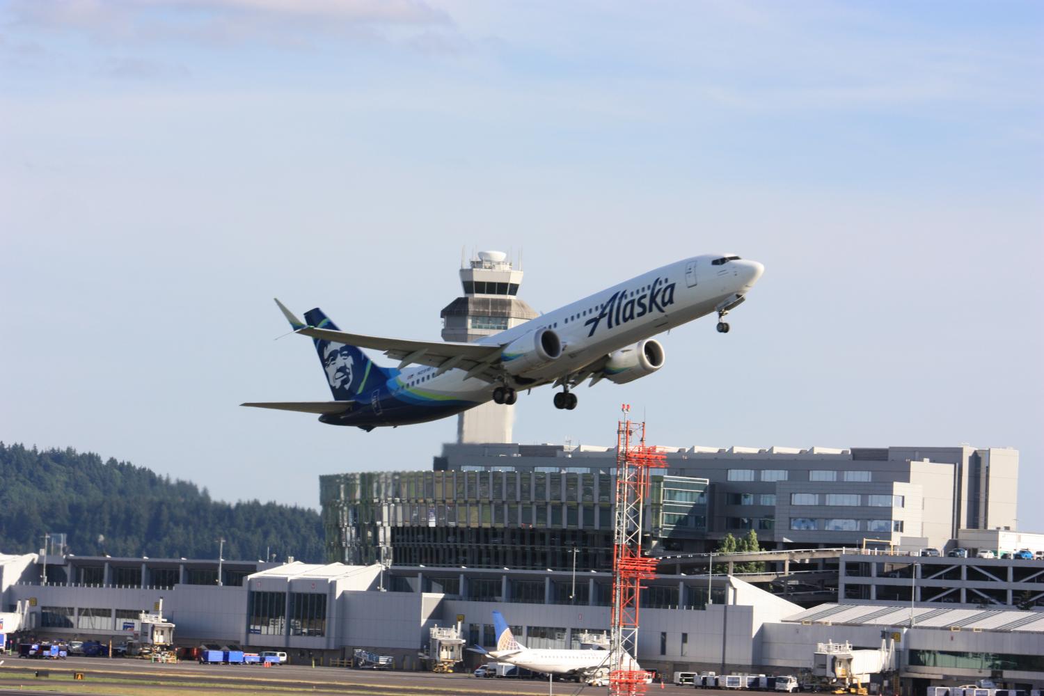
- Seattle is the headquarters hub of Alaska Airlines and its regional subsidiary Horizon. But Portland is also a secondary hub for Alaska and Horizon.
- Seattle has far more international routes than Portland. Portland has enough to be interesting, including regular scheduled widebody aircraft for passengers and cargo.
- PDX is a mixed-use civilian/military airport with the Portland Air National Guard Base on the south side of the airfield. None of the Seattle-area airports is mixed-use. (Military logistics at PDX also became a big deal in the 2025 Olympic Pipeline shutdown. Some transpacific flights stopped at PDX for fuel when SEA had a shortage. When SEA ran out of fuel, PDX had alternative fuel due to planning done for its military base.)
Another interesting aspect of Portland for aviation geeks is that it has a Boeing paint hangar. Of course, Seattle dominates that aspect because Boeing Commercial Airplanes has two major factories there: wide-body jets at Everett's Paine Field (PAE) and narrowbody jets at Renton Municipal Airport (RNT). Both those airports have paint hangars. But they aren't enough to keep up with current plane production. So some planes get flown out unpainted, with a green vinyl protective coating, to get painted at either Seattle Boeing Field (BFI), Portland (PDX) or Southern California Logistics Airport in Victorville (VCV). Some airlines arrange their painting to be done at other airports. There is no Boeing paint hangar at Seattle-Tacoma SEA. So this adds to the interesting mix for planespotting in Portland.
I've found that bicycling has advantages for planespotting at PDX Airport. Airports of course are busy places with limited parking. Some good spots at PDX are only easily accessible by bicycle. I'll share my experiences here on getting to the airport and where the viewing spots are.
Though pedestrians can access all the points too, if you take transit or find a place to park. It's just a lot slower.
I post aviation interests including PDX on my @ikluft@avgeek.social account on Mastodon. Also have a look at my thread on comings and goings from the Boeing Portland Paint Hangar.
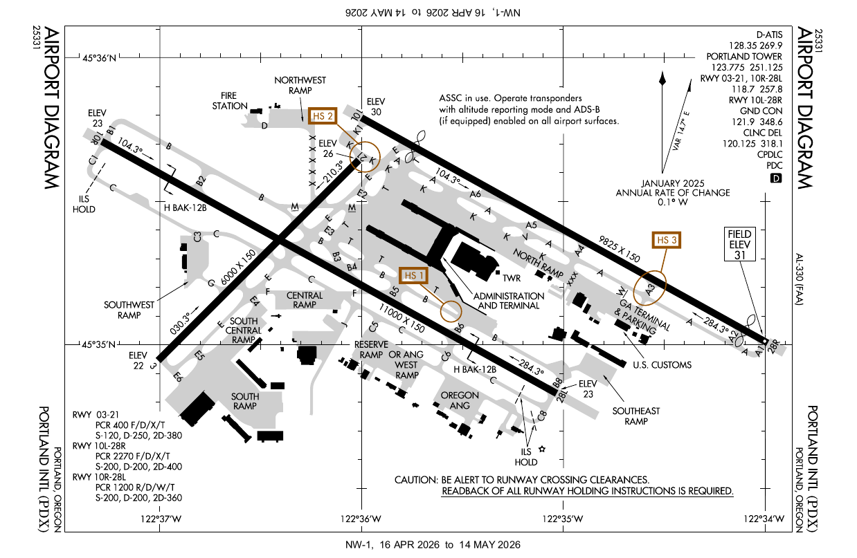
Airport diagram
Safety
Some safety tips are in the "prepare for the worst" category, unlikely to happen but better to have thought about ahead of time.
- Bring hearing protection and be ready to use it. Jets can be loud enough to cause incremental hearing loss. Anywhere around the south-side runway 10R/28L, there's a possibility that Oregon Air National Guard F-15s will take off. But any jet that goes around will also go to full power. Those are the loudest normal circumstances.
- Don't fly drones near the airport without permission. Drones are a collision hazard for airplanes and helicopters. Portland International Airport has Class C airspace at the surface out to 5 miles away. Air Traffic Control Tower permission is required to fly drones at or near the airport. See the FAA's "Unmanned Aircraft Systems (UAS)" info page and Port of Portland's "Unmanned Aircraft Systems (UAS) Operations" page.
- Don't loiter in places lined up with the runway centerline. Even though aircraft accidents are extremely rare, those are the places they would be most likely. Stay on the side of statistics and don't hang around for extended periods there. Those are considered "clear areas" or "runway safety areas" for safety reasons. In case of an aircraft making a runway overshoot, undershoot or excursion, any such event could be made worse if people are hanging around there. So when in the extended centerline within 1000ft/300m of a runway, take your pictures and then get out of there.
- If you see an aircraft accident, the control tower probably knows about it if it's on the airfield. Though if it occurred off-airport or you have reason to doubt the tower was able to see it, call 911 to report it including a location for emergency responders. Photos or video should be made available to the NTSB for any investigation.
Security
Planespotters have excellent access at PDX. We should not take that for granted. Let's encourage each other to work together to make sure we don't lose our privileges. At all airports, planespotters need to try to be an ally of the airport's security. If not, we could see new restrictions on our access. So it's important to be well behaved, help set a good example for others and educate or discourage anyone who sets a bad example.
Don't touch airport perimeter security fences. Assume that doing so will at least catch attention, and may be considered a security incident.
When planespotting in the airport parking structures, assume you're in view of cameras at all times. Whether being watched live or on footage reviewed later, make it obvious from your behavior that you are there to see airplanes. Allow some room from parked vehicles as best you can. Don't show interest in parked vehicles, except for your own if you drove there.
If approached by the Portland Airport Police (part of the Port of Portland) or other law enforcement, be cooperative and friendly. If asked, tell them what you're doing. Comply with any instructions they give you, keeping in mind they may have info they can't disclose at the time. As public safety and emergency responders, we all need what they do. All of us need to sustain a community relationship that planespotters are their allies.
If you see a security incident or suspicious activity, call either the Portland Airport Police or 911.
Getting to PDX
Planespotters have options to get to PDX by car, transit or bicycle. Some locations are only really accessible by bicycle. I'll lump scooters in with bicycles since they can usually use the same routes. Rental bikes and scooters have geofenced boundaries which may not access the whole area.
Driving to PDX
Driving to PDX, use either NE 82nd Ave / State Route 213 or Airport Way and follow signs to short-term parking (north side) or long-term parking (south side) at the terminal.
Taking transit to PDX
If you don't want to pay for parking or mess with traffic at the terminal, an alternative is to park at a TriMet transit center and take the MAX Red Line light rail to the airport. The closest free parking lots are at Gateway/99th Ave Transit Center and Parkrose/Sumner Transit Center. (See TriMet's transit centers in Portland.)
The transit card for the Portland metro area (including C-TRAN in Vancouver/Clark County WA) is the "Hop Fastpass" or just "Hop Card". If you don't have a Hop Card for riding transit, you can buy them at MAX stations or some local stores. You can also tap a chip-equipped credit card at the station before boarding a MAX train. If you want to minimize costs, note the "valid until" time when tagging in, 2-1/2 hours later. Be sure to tag in and board a return train before then so it will be on the same fare. Otherwise a second TriMet fare with the same card the same day will become a day pass. See TriMet's fare info.
Bicycling to PDX
For cyclists, Portland Airport can be reached from most directions, some more or less direct than others. It's best to stick to bike paths and roads with bike lanes. Avoid or use extreme caution on roads which have no bike facilities.
| Bicycle and Pedestrian Access to PDX | ||
|---|---|---|
| From | Route | Cyclist access |
| MAX light rail | Red Line | excellent 🟢 |
| East Portland | NE 82nd Ave | avoid ❌ - use I-205 path |
| Outer East Portland to Gresham | I-205 path | excellent 🟢 |
| Hollywood district | NE 33rd Ave to Marine Drive Path | caution for traffic 🟡 |
| North Portland | Marine Drive and Marine Drive Path | caution for traffic 🟡 |
| Fairview to Troutdale | Marine Drive and Marine Drive Path | caution for traffic 🟡 |
Airlines at PDX
Airlines at PDX are mostly mainline carriers but have some changes occasionally. As a planespotter, you'll want to keep in mind which terminal an airline uses in order to make an educated guess which runway they'll use. (More on runway selection is below at "Which runway to choose".)
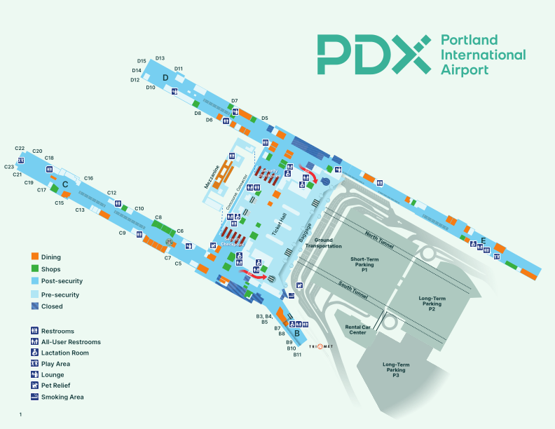
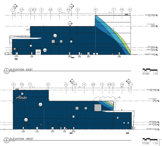
from PDF printable copy of Portland Airport terminal map by Port of Portland, June 2026
Here's a list of airlines and which concourses they use, as of March 2026. (Airlines listed alphabetically for objectivity.)
- Concourse A (no longer exists)
- Concourse B (regional carriers: Alaska hub, OneWorld alliance)
- regional carriers: Alaska operated by SkyWest (contract regional airline), American Eagle, Horizon Air (Alaska regional subsidiary)
- Concourse C (mainline carriers: Alaska hub, OneWorld alliance)
- Alaska, American, Hawaiian
- other carriers: Frontier, JetBlue
- Concourse D (international arrivals, Delta/SkyTeam alliance and others)
- international gates at west end: Air Canada Express (regional) 🇨🇦, British Airways 🇬🇧, Condor 🇩🇪, IcelandAir 🇮🇸, KLM 🇳🇱, Volaris 🇲🇽, WestJet Encore (regional) 🇨🇦
- Allegiant, Delta, Delta Connection operated by SkyWest (contract regional airline)
- Concourse E (United/Star Alliance and Southwest)
- Southwest, United, United Express (regional)
Here are the users of other parts of the airport.
- North Ramp (Fixed Base Operators/FBOs)
- Very small airlines: Boutique Air, Seaport Airlines
- Charter flights and transient General Aviation
- Visiting military aircraft (i.e. for refueling), if not parking at Oregon Air National Guard
- South Ramp (cargo, maintenance)
- Cargo airlines (ABX/DHL, Amazon cargo contractors, FedEx, UPS)
- Boeing paint hangar (new aircraft for painting, crew transport turboprops)
- Horizon Air maintenance base (originally Air Oregon maintenance, acquired by Horizon then Alaska), Alaska Airlines widebody maintenance hangar (groundbreaking was June 16, 2026, estimated 2 years to build)
- Military Ramp
- Oregon Air National Guard 142nd Wing: 123rd Fighter Squadron, 123rd Weather Flight Squadron, 125th Special Tactics Squadron
- USAF Reserve 304th Rescue Squadron
Which runway to choose
Airplanes take off and land into the wind. Check the NWS forecast for PDX and METAR & TAF for PDX (observed conditions on Meteorological Aerodrome Report and upcoming Terminal Area Forecast) to get an idea which runways will be in use and select your viewing location.
The official airport conditions are transmitted on the Automated Terminal Information System (ATIS), which is 128.35MHz at PDX. If you have a scanner, you can listen directly. Online, digital ATIS (D-ATIS) is available at various sites that display the FAA data feed, such as
Portland's main runways are numbered 28L/10R and 28R/10L. The numbers are the compass directions with the last digit removed, so approximately 280 degrees when landing and taking off westbound, or 100 degrees when eastbound. Since there are two parallel runways, they have a right (R) and left (L) suffix.
Here are some things for planespotters to watch for on the D-ATIS.
- CLSD
- stands for closed. You may see it with runways or taxiways. Runways in particular are what you're looking for so you don't get in position at a closed runway.
- SIMUL
- stands for simultaneous approaches and departures. It indicates the parallel runways are both open and in use at the same time. However, this is only for good weather. In poor weather (Instrument Meteorological Conditions, IMC), both runways can be in use but SIMUL will not be shown because the runways are too close to each other for simultaneous instrument approaches or departures. So an approach or departure for one runway blocks airspace of the other. Pilots will still request an approach to whichever runway is closest to their terminal and gate or parking.
- OTS
- stands for out of service. It indicates some equipment is not operating. When paired with a runway's ILS (instrument landing system) it means some flights may go for the other runway, if available. This is less significant than it used to be since most aircraft (particularly all airlines) at PDX can use GPS approaches when radio navigation is out.
You can anticipate planes will be landing and taking off into the wind. Use the direction the wind is reported or forecast to come from as the expected runway direction. When winds are coming from 280 degrees, roughly from the west, it lines up with Runways 28L and 28R. Likewise winds from the east line up with Runways 10L and 10R. Wind can come from any direction and doesn't necessarily line up with runways. So pilots and air traffic controllers use the closest direction. Crosswind landings are routine as long as they're within the capabilities of the crew and aircraft. When winds are calm, PDX uses Runways 28L and 28R.
There is a shorter crosswind runway 3/21 which is less-used because it crosses the big runway 10R/28L. Runway 3 is restricted to the first 3000ft before the intersection with 10R/28L. Runway 21 is treated as closed. In case of an emergency, the tower can waive those restrictions. The main users are FedEx regional feeder turboprops landing on Runway 3, generally only turboprops for the central and south ramp.
- 28L/10R is south of the terminal, near the Portland Air National Guard Base
- 28R/10L is north of the terminal, near the Columbia River
When both runways are open, planes usually request (but don't necessarily always get) the runway closest to their arrival gate or destination on the airfield.
- Alaska, American, Frontier, Hawaiian, Horizon and JetBlue (Terminals B and C) are usually on Runway 28L/10R.
- Southwest, Delta, United and international arrivals (Terminals D and E) are usually on 28R/10L.
- International departures and heavy aircraft (767, A330 and larger) prefer 28R/10L because it's the longest runway. Longer takeoff allows a higher takeoff weight with higher total of fuel, passengers and freight.
- Oregon Air National Guard F-15s prefer 28L/10R, next to the Oregon ANG Base. However visiting military aircraft may use 28R/10L if refueling at the FBOs at the north ramp.
- Cargo aircraft prefer 28L/10R for the shortest taxi to the central and south central ramp.
- New Boeing airplanes from the factories or from storage: incoming unpainted and outgoing newly-painted planes prefer 28L/10R for proximity to the Boeing Portland Paint Hangar at the south ramp. However, Boeing test pilots have used 28R/10L fora touch-and-go landing/takeoff operations during flight testing of a new aircraft.
It's also possible to look up Notices to Airmen/Notices to Air Missions (NOTAMs) yourself. The FAA issues information about airports and airspace. Check https://notams.aim.faa.gov/notamSearch/ and search for "PDX". NOTAMs are heavily abbreviated and take some learning to deal with. For example, you can check when a runway closure is scheduled or when a current closure will end. To get started, like with ATIS info above, you'll look for runway closures with the codes RWY and CLSD. All times are in UTC (abbreviated Z for Zulu Time).
Planespotting places at PDX
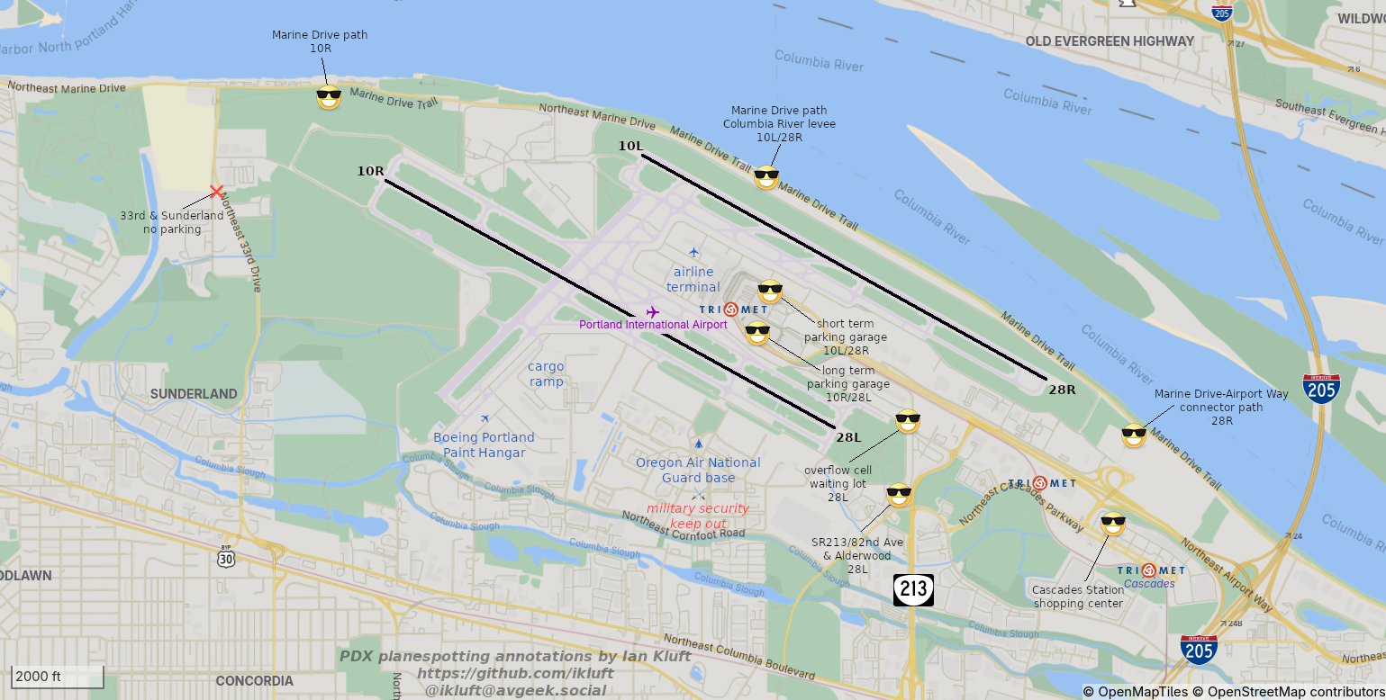
map from OpenStreetMap data, annotations by Ian Kluft
(see map image)
Planespotting areas at PDX vary in accessibility, some only accessible by bicycle. They are marked on the map with a sunglass-smiley icon 😎. In the parking structures, in case of rain you can find cover one floor lower.
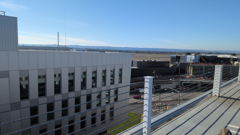
long term parking structure: 4th or 5th floor, south side near "sasquatch" elevators
| Views | south to Runway 28L/10R |
| Accessibility | car, transit, bicycle |
| Lighting |
near side of aircraft on or parallel to runway heading
daytime: shaded sunrise: illuminated late January to mid November sunset: illuminated mid May to late July |
Use the "sasquatch" elevators to get to the south side of the long-term parking structure where there's a view of Runway 28L/10R. The 4th floor has a view across the area. The 5th floor has a view to the southwest, but is set back from the runway and blocked by solar panels to the south. In case of rain, the 3rd floor has cover but a less elevated view.
When bicycling in the parking structures, actively yield to pedestrians with luggage and motion to them to proceed. If they seem surprised, tell them "you get priority here." It's our part of being good guests at the airport.
far background: tree-covered Rocky Butte cinder cone volcano
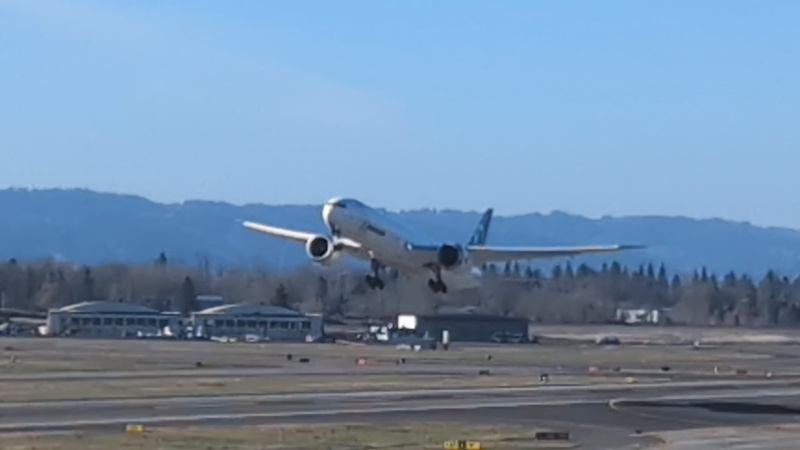
July 24, 2025
photo by Ian Kluft
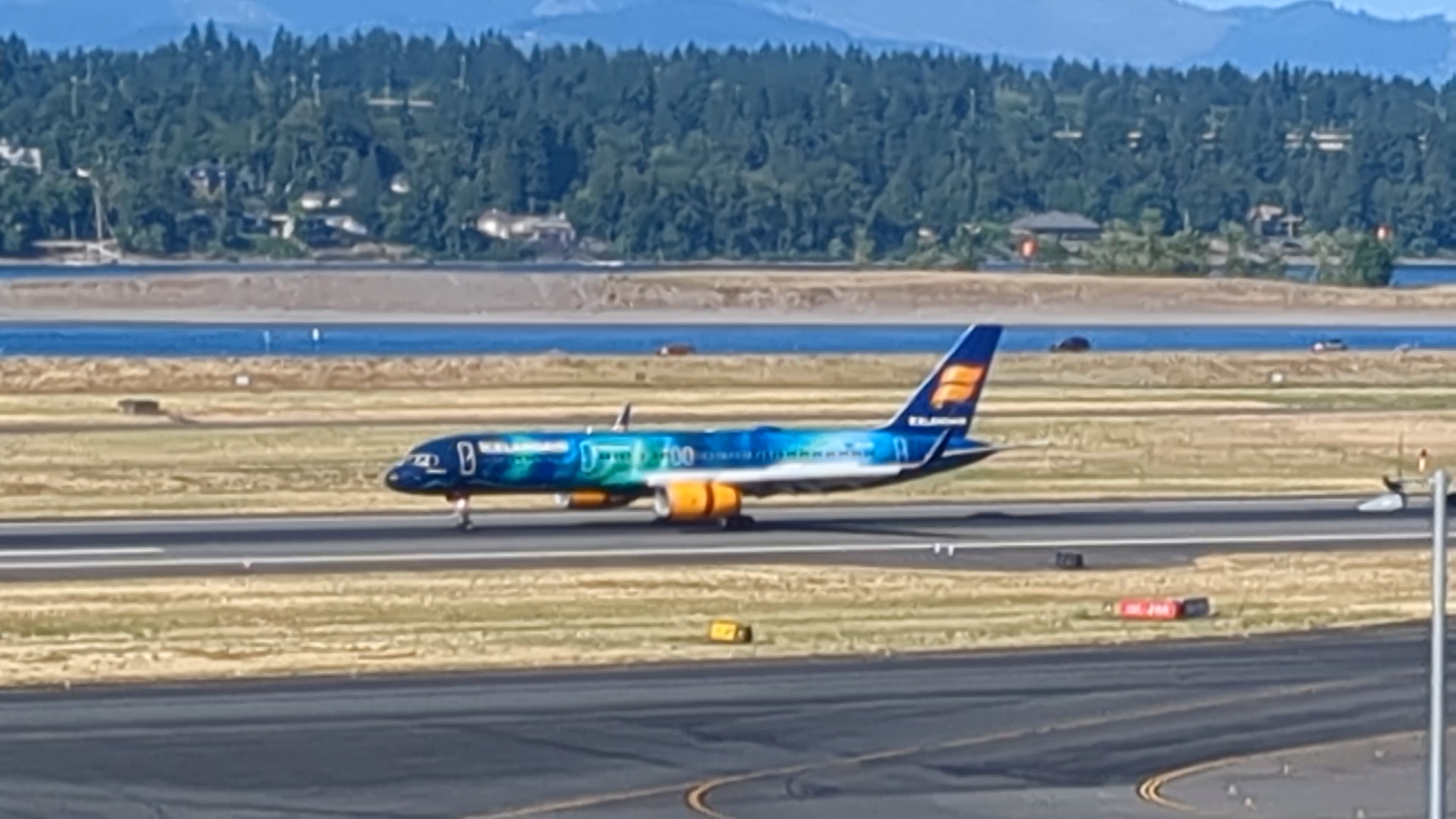
(screenshot from a video I posted on Mastodon)
January 21, 2026
photo by Ian Kluft
short term parking structure: 7th floor, north side near "duck" and "salmon" elevators
| Views | north to Runway 28R/10L |
| Accessibility | car, transit, bicycle |
| Lighting |
near side of aircraft on or parallel to runway heading
daytime: illuminated sunrise: illuminated late November to mid January sunset: illuminated early August to early May |
Use the "duck" or "salmon" elevators to get to the north side of the short-term parking structure where there's a view of Runway 28R/10L. The 7th floor is the roof. In case of rain, there's cover one level below.
When bicycling in the parking structures, actively yield to pedestrians with luggage and motion to them to proceed. If they seem surprised, tell them "you get priority here." It's our part of being good guests at the airport.
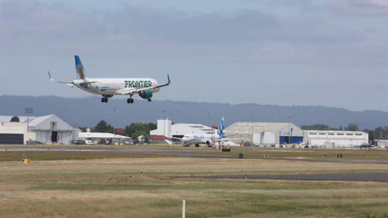
background: Columbia River (Oregon/Washington border)
July 15, 2025
photo by Ian Kluft
cell phone waiting overflow lot
| Views | south for Runway 28R |
| Accessibility | car, bicycle |
| Lighting |
near side of aircraft on or parallel to runway heading
daytime: shaded sunrise: illuminated late January to mid November sunset: illuminated mid May to late July |
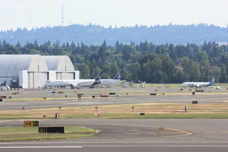
Separate from the primary cell phone waiting lot (nearby next to 7-Eleven and Dutch Brothers Coffee), the overflow cell phone waiting lot is a great planespotting area. It's on NE Air Cargo Road, with parking spots facing the Runway 28L threshold.
The lot is intended for very short-term use. If the lot is or becomes almost full, yield to people picking up travellers and spot somewhere else. Posted signs require drivers to stay with their vehicles. To stay on the right side of airport security, be sure not to touch the airport perimeter fence. If you need a step ladder to take pictures over the fence, set it up by your vehicle. Alternatively, find a friend with a pickup truck (unless you have your own) and stand on the truck bed.
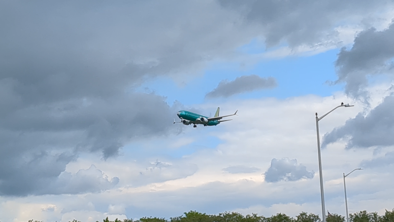
background: a newly-painted SCAT Airlines (Kazakhstan) 737 MAX8 taxiing from the Boeing paint hangar
June 5, 2025
photo by Ian Kluft
SR213/82nd Ave and Alderwood
| Views | north for Runway 28R arrivals |
| Accessibility | bicycle |
| Lighting |
near side of aircraft on or parallel to runway heading
daytime: illuminated sunrise: illuminated late November to mid January sunset: illuminated early August to early May |
The intersection of NE 82nd Ave (State Route 213) and NE Alderwood Rd is good for views of 28L arrivals low and nearly overhead with the sun behind you. But there's nowhere to park. So consider this only accessible by bicycle for photography.
There are sidewalks on both sides of 82nd. On the east side you can get pictures of the planes coming with no cars in the view. On the west side you can stand on the retaining wall between the sidewalk and the road to get pictures over the airport fence.
May 22, 2025
photo by Ian Kluft
Marine Drive multi-use path on top of Columbia River levee
| Views | south to Runway 28L/10R |
| Accessibility | bicycle |
| Lighting |
near side of aircraft on or parallel to runway heading
daytime: shaded sunrise: illuminated late January to mid November sunset: illuminated mid May to late July |
The Columbia River levee alternates between having either Marine Drive or the multi-use path on top. The path overlooks Runway 10L/28R where it's on top of the levee just east of Broughton Beach. To get there, it's 2 miles west from the I-205 path or 1 mile east from Marine Drive and 33rd Ave.
Since you're looking south from here, consider sun angles for morning and afternoon. In most cases you don't want the sun behind the aircraft.
This is the area where you can view the Boeing Portland Paint Hangar with binoculars or an optical-zoom camera.
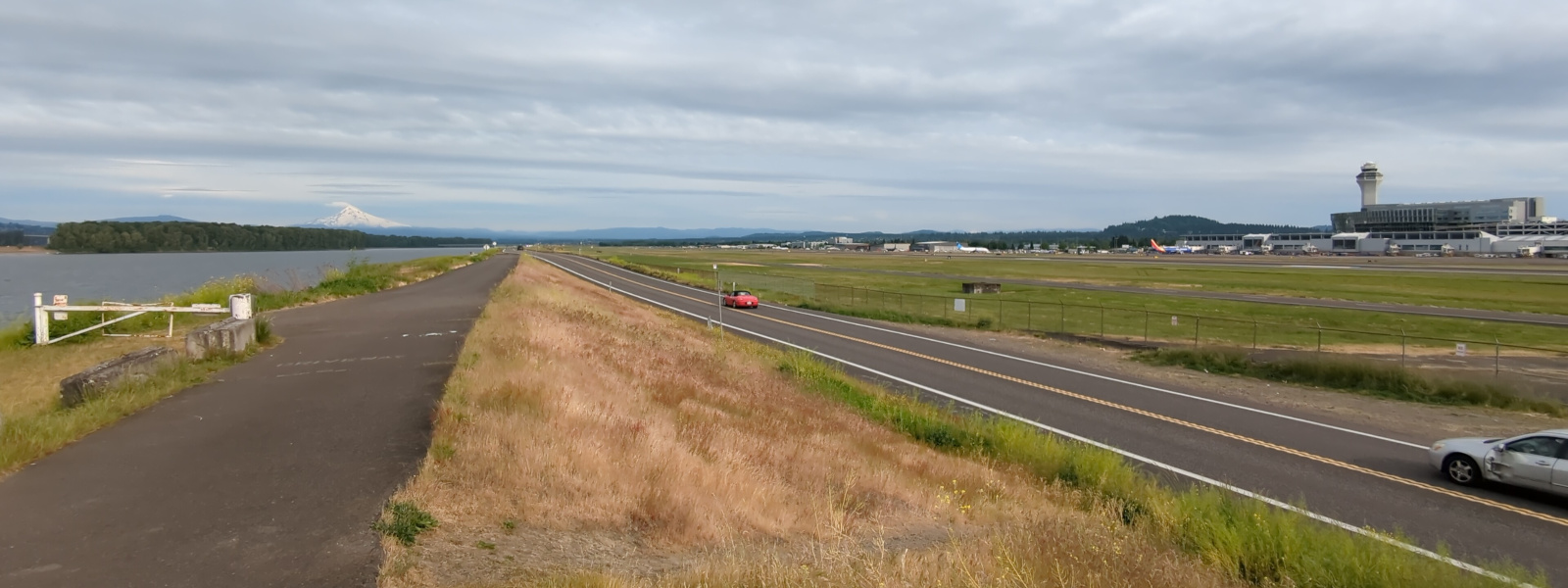
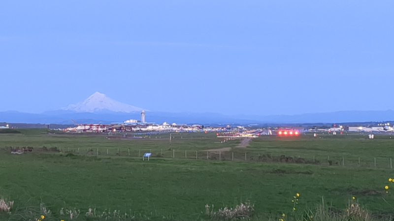
background: snow-capped Mount Hood at 40 miles / 65km distance
May 10, 2025
photo by Ian Kluft
background: Concourses D & E, Port of Portland headquarters offices and PDX Air Traffic Control Tower
May 20, 2026
photo by Ian Kluft
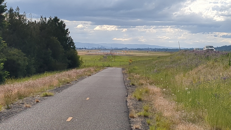
Marine Drive multi-use path between Broughton Beach and 33rd Ave
| Views | south to Runway 28L/10R arrivals |
| Accessibility | bicycle |
| Lighting |
near side of aircraft on or parallel to runway heading
daytime: shaded sunrise: illuminated late January to mid November sunset: illuminated mid May to late July |
Along the Marine Drive multi-use path near 33rd Ave, there are views of Runway 28L/10R, the big runway on the south side. There is no longer anywhere safe to park on 33rd for aircraft photography after the city blocked off the triangular lot at NE 33rd Ave and NE Sunderland. So that leaves bicycling to this spot to get a place you can stop and take pictures of 10R arrivals.
On a clear day with Mount Hood in the background, this spot has great potential for some iconically-Portland views of the airport.
Note: If you don't have an Oregon Metro Parks parking pass, then Broughton Beach is not a place to consider parking. Use a bicycle to get to the Columbia River levee path.
background: snow-capped Mount Hood at 40 miles / 65km distance
April 13, 2025
photo by Ian Kluft
Marine Drive - Airport Way connector path
| Views | Runway 28R/10L |
| Accessibility | bicycle |
| Lighting |
looking up at airplanes, mostly shaded
sunset behind takeoffs around early-mid May and late July |
There's a bike/pedestrian path between Mount Hood Avenue and the Marine Drive multi-use path. Like many other places, the crossing at Marine Drive has button-activated flashing lights, but not a full traffic signal. The usual caution is to beware that some drivers don't stop. At least the crossing of Airport Way (the busiest surface street in Oregon) is via the Mount Hood Avenue overpass.
June 14, 2024
photo by Ian Kluft
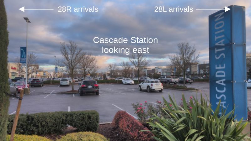
Cascade Station shopping center
| Views | between 28R and 28L approaches |
| Accessibility | car, transit, bicycle |
| Lighting | daytime: 28R arrivals illuminated, 28L arrivals shaded |
The Cascade Station shopping center is easy to get to. It has free parking. There are also two MAX light rail stations: Cascades or Mount Hood Ave. Officially the shopping center is "Cascade Station" and the MAX train station is "Cascades Station". In practice, since they're at the same place, everyone understands if you use either name.
When winds favor Runways 28L and/or 28R, landing aircraft pass low to both the north and south. For 28R (north side by the river), they can be low enough you'll need to search for a view between trees. It's harder to see departing planes from 10L and 10R because the steeper angles maker them farther away. Nothing here is as close as being at the airport. But especially with an optical zoom camera, you can make it work.
January 5, 2026
photo by Ian Kluft
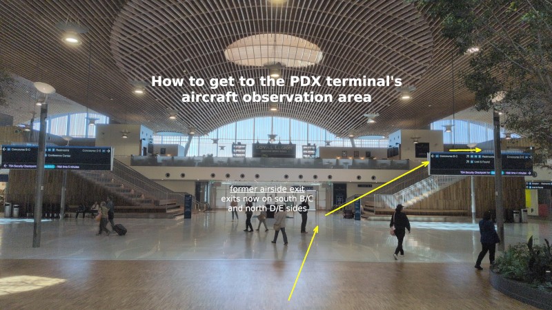
Terminal overlook at interior gates
| Views | gates between Concourses C and D including international arrivals |
| Accessibility | landside (outside TSA security) in terminal, up stairs at passenger arrival waiting area |
| Lighting |
near side of aircraft illuminated in mornings
night photography works for parked planes |
A nice feature of the new terminal building that opened in 2024 is that it's possible to get a view of the taxiway between the C and D concourses without going through the TSA checkpoints. To get there, you can climb the stairs in the area between the north and south TSA checkpoints and next to the passenger exit from the security perimeter.
The wall below the upper viewing area level used to be the airside passenger exit until April 2026. The passenger exits were split up to south B/C and north D/E exits. There was also a change on the upper level viewing area: the area on the left is no longer accessible due to construction of a conference center. Under the new configuration, go up the right-side steps and around to the viewing area in the back. Also, the Loyal Legion Beer Hall on the upper level is a restaurant with some of its seating also viewing the airport ramp between the terminals. I haven't tried them - so I don't have any recommendations yet.
Don't take pictures in the directions of the TSA checkpoints, nor appear to do so. While photography isn't technically illegal, TSA at various airports have been observed making a fuss. In case of a dispute around the checkpoint, they're going to win even if due to improper training. So don't hold up that lightning rod. Avoid creating a situation that could threaten our avgeek view access.
May 2, 2026
photo by Ian Kluft
November 24, 2025
photo by Ian Kluft
December 31, 2025
photo by Ian Kluft
Places not to go for planespotting
Former planespotting places
These locations are no longer usable for planespotting. But some outdated advice and discussion are still around the Net which refer to them.
- The south side of the 7th floor of the short-term parking structure no longer has a complete view of Runway 10R/28L, just a partial view to the southwest. The Rental Car Center's office building was completed in 2021, blocking the view to the southeast. Instead use the long-term parking structure for a full southern view to Runway 10R/28L.
- The triangular lot at NE 33rd Ave and NE Sunderland is no longer available for parking for aircraft photography or any other purpose. That location was used for partial view between trees of 10R approaches. The city blocked off the lot to deter its use as a homeless RV encampment. Instead use a bicycle to access the Marine Drive multi-use path.
January 21, 2026
photo by Ian Kluft
June 4, 2025
photo by Ian Kluft
Broughton Beach
Broughton Beach is along Marine Drive and the Columbia River levee path, next to the portion overlooking Runway 10L/28R. But it has no free parking. Oregon Metro Parks parking passes apply if you have one. There are occasional scheduled free parking days - see Oregon Metro's list. Otherwise it's $5 per car every visit (as of July 2026). If you don't have a pass and don't want to pay every time for parking, don't consider this spot. Free access to the levee trail is mainly by bicycle. (Rental scooters and ebikes may be geofenced out of the river path and/or the airport.)
South side inaccessible for photography
Unfortunately, there are no photography spots with public access on the south side. It would have been nice to have a spot with the sun behind you. With the military base, cargo ramp and a wetland preserve, the few places there's any small view there's a fence in the way. Instead, get views of Runway 10R/28L from the top of the parking structures at the airline terminal. Take advantage of early morning and late afternoon sunlight angles, whichever is more advantageous for the view.
Central Ramp/Cargo
July 12, 2025
photo by Ian Kluft
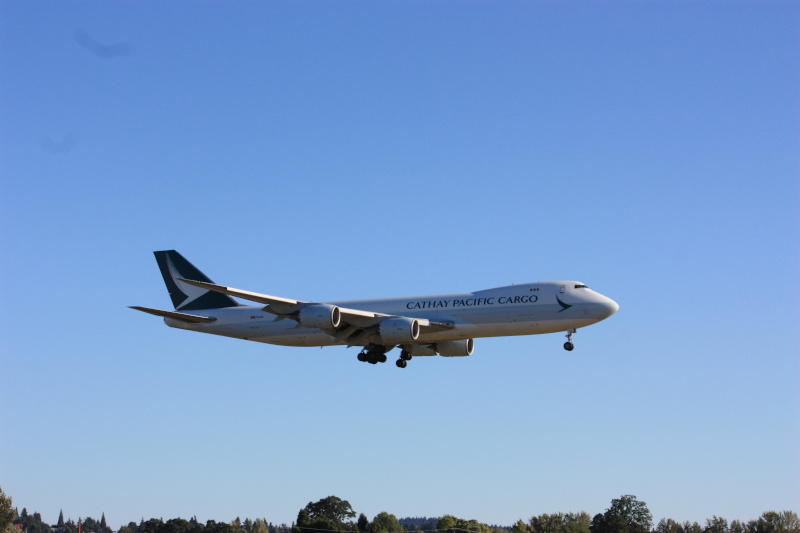
The areas listed in the airport diagram as "central ramp", "south central ramp" and "south ramp" are mostly cargo facilities. Cargo operators there include FedEx, UPS, USPS, Cathay Pacific Cargo and others. Amazon cargo contract flights are operated by Sun Country 737-800F (merger into Allegiant in progress) and Alaska A330-300F (from Hawaiian acquisition), painted Amazon but using flight numbers of the operator.
There are no good spots for photography in the cargo ramp area. Fences are in the way. Remember, do not touch security perimeter fences even to hold a camera up to them. The best pictures, even with challenging sunlight angles, are from the long term parking garage and cell phone waiting lot. The best views with the sun behind you are from 82nd/Alderwood - but there's no parking so consider that mainly bicycle and scooter access.
There's also the Boeing Portland Paint Hangar with its own section below. It's in the south ramp area next to the Runway 3 threshold.
A majority of the widebody aircraft at PDX are cargo, particularly FedEx and UPS. A few times each week, Cathay Pacific Cargo flies a 747-400F or 747-8F freighter up from Los Angeles LAX or Mexico City NLU, and departing to Anchorage ANC on the way back to their hub in Hong Kong.
Horizon (current) and Alaska (future) maintenance
Hard to see deep inside the cargo area and next to the military base is the Horizon Air maintenance base. When Horizon has orders for new Embraer E175s, which are almost complete with 2 left as of July 2026, deliveries of new airplanes are ferried to Horizon's PDX base for a few days of fleet induction work before entering revenue service. In the future when they order more airplanes, new ones will presumably be ferried here again. A delivery flight is a rare moment when a plain regional jet becomes an avgeek curiosity.
Adjacent to the Horizon hangar, their parent company Alaska Air Group is building a widebody maintenance hangar for the 787 and A330 aircraft they got in the Hawaiian Airlines acquisition. Hawaiian and Amazon A330s operated by Alaska already fly to PDX. Once the new hangar opens, we can expect to see Alaska 787s come to PDX occasionally when they need to go to the hangar. Without any scheduled Alaska 787 flights at PDX, they might be ferried from SEA empty, or up-gauge a SEA-PDX flight that would have been on a 737. You'll have to be alert to catch them. See near-term plans for more on the Alaska maintenance hangar plans.
Alaska has been ferrying new 737 and 787 airplanes to Los Angeles LAX for fleet induction work. We'll have to see what, if anything, changes when Alaska's PDX maintenance hangar is built by 2028.
All the cargo operations add up to a steady stream of planes coming and going from the runways, usually 28L/10R since that's closest. Some smaller turboprop planes including FedEx feeders land on Runway 3 for short taxi to the cargo ramp.
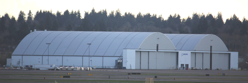
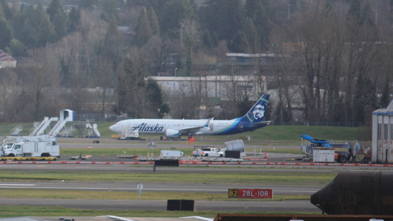
Boeing Portland Paint Hangar
January 5, 2026
photo by Ian Kluft
Two 787-9s in Lufthansa and LOT Polish Airlines liveries are in front of the Boeing Portland Paint Hangar. The Lufthansa plane was repainted from a cancelled order by another airline. And the LOT plane had just landed, ferried by Boeing for repainting to Lufthansa as well. 737 MAX9 N704AL from AS1282 is parked to the right in the corner of the Boeing ramp.
May 20, 2026
photo by Ian Kluft
The Boeing Portland Paint Hangar is in a back corner of the field which is difficult to see. That's probably on purpose. But planes coming and going use the runways. When you are aware of a plane arriving for painting or departing with new paint, vantage points for Runway 10R/28L are the best options for photos. The PDX paint hangar has two "bays" (separate parts of the hangar) which can accommodate wide-body jets.
Boeing does not announce activities at the paint hangar. When possible they prefer to use paint hangars at the same airport with the assembly line - in Renton RNT for most 737s and in Everett PAE for 767, 777 and 777X. Boeing is expanding 737 production by mid-2026 so MAX10s will be assembled in Everett, using space vacated in 2023 by the end of 747 production. There are also paint facilities at Boeing Field BFI in Seattle. Only when Seattle area paint hangars are booked, Boeing uses paint hangars outside Seattle, including Portland PDX and Victorville VCV (Southern California Logistics Airport).
Planes come to PDX for painting often enough to keep things interesting. The planes painted in PDX are all still pre-delivery, owned by Boeing and using a Boeing flight number. Many come to PDX on their first flight.
When a new unpainted plane arrives, metal planes (everything except a 787) are almost all green with a protective vinyl coating which will be removed in the paint hangar. Usually the rudder and winglets are pre-painted, offering the big hint who the customer is. You may also see a hint in the ADS-B telemetry indicating which country the plane will be registered to. Initially when a plane arrives, it has a "manufacturer temporary" registration number on the tail. Coming out of painting, it will have its permanent registration reserved for the customer. (If it still displays a registration assigned to Boeing, that tells you something different is going on. Prototypes are usually painted in Seattle. So that would likely mean it's not ready for delivery and would then fly somewhere with storage parking.)
In general, you can expect it to take 10-14 days to paint a 737, or 3-4 weeks for a wide-body. Sometimes a plane may stay longer if it's getting more work done than just paint.
The first flight is called the "B1" flight because it is flown by Boeing test pilots. These flights often go first to eastern Washington state and do lots of maneuvers while the test pilots check that all the systems are working as expected. (A vast number of tests are done on the ground before flight, including engine runs, control surface movement, landing gear swing and electronics checkout.)
When leaving the PDX paint hangar, the plane may do test maneuvers again, either a "B2" flight completing tests not done on the B1 or a "C1" flight by customer pilots for acceptance testing. Generally a newly-painted plane will fly to the airport with a Boeing Delivery Center where the purchase will be completed and the customer will take the aircraft. 737s are usually delivered from Boeing Field BFI. 767s and 777s are usually delivered from Everett PAE. The new 777X (-9 and -8) will be processed the same as the old 777-200 and 777-300. In any case, the plane is not ready until the test pilots say it's ready.
787s are no longer assembled in Everett since 2021. But some planes have needed rework (to correct errors or for cancelled orders) and were flown to Everett for that. For those, repainting can be done at PDX. But generally new 787s are now painted where they are built in Charleston CHS.
In rare circumstances, if a customer is not ready for delivery (or has gone out of business) the plane will be flown to storage at places such as Moses Lake MWH or Victorville VCV for storage, possibly wait until a new customer is found. Some airlines have taken advantage of that situation to get planes faster than the long production backlog and/or at a discount. But they do require reworking the interior to the buyer's branding.
Planes coming or going from the PDX paint hangar are usually paired with a Boeing Crew Transport plane to fly the test pilots back to BFI/PAE or fly them down to PDX before flying out a newly-painted plane. These crew transport planes are currently single-engine turboprops such as a Pilatus PC-12 or Cessna 208. They can be recognized for flying with a Boeing company radio callsign and flight number.
I have a thread on Mastodon (avgeek.social) started in April 2025 on comings and goings from the Boeing Portland Paint Hangar. As I spot new ones, I add them to the thread.
N704AL still at PDX after Alaska 1282 blowout
January 5, 2026
photo by Ian Kluft
One curiosity that I got a picture of was N704AL, the Boeing 737 MAX9 from Alaska Airlines Flight 1282, was still in Portland 2 years after the door blowout incident of January 5, 2024. At the time of this photo, it had never flown again. Boeing bought the plane back from Alaska to support NTSB investigation access for an extended period of time. With the NTSB final report published, I expect Boeing will eventually repair and sell it. But in this photo, plastic sheeting still covered where the door plug had not yet been replaced.
As long as N704AL remains parked outside, it can be seen on the Boeing ramp near the paint hangar. I got this picture from the Columbia River levee path near Broughton Beach and the approach end of Runway 10L at a distance of 1.4 miles / 2.3 km. You will need a camera with optical zoom to get any detail.
N704AL was still at PDX last time I checked as of May 20, 2026.
Future plans
Near-term plans
In near-term plans, Alaska Airlines is building a maintenance hangar with capacity for two widebody or 3 narrowbody planes. This is a timeline of the news.
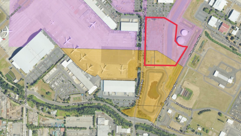
- February 18, 2026: Portland City Council made details public probably earlier than they would have because an "enterprise zone" boundary needed to be adjusted to fully include the property for a new maintenance hangar project planned by Alaska Airlines.
- April 8, 2026: Port of Portland announced that Alaska Airlines leased land for the hangar.
- June 16, 2026: Alaska Airlines announced they broke ground on the new widebody hangar. Estimated 2 years to completion.
Alaska's acquisition of Hawaiian Airlines notably brought in Airbus A330-200 and Boeing 787-9 widebody airliners to their fleet as part of the deal. But of course the only maintenance hangar owned by Alaska that can fit these big planes is also from Hawaiian, at Honolulu Airport HNL. And it's only big enough for one widebody plane. There was already speculation among avgeeks about where Alaska would build a widebody-sized maintenance hangar on the mainland. There is no room at Alaska Airlines' headquarters at Seattle-Tacoma Airport SEA, limited to a flat area on top of a hill. Alaska's existing maintenance hangar at SEA can only fit narrowbody 737s. The SEA master plan shows shrinkage of the cargo ramp to make room for a new passenger terminal. So it turns out Alaska decided to put the A330/787 maintenance hangar at their secondary Pacific Northwest hub in Portland PDX. Lucky for us! It's under construction next to the maintenance hangar of Alaska's regional subsidiary Horizon Air.
Portland City Council, February 18, 2026
Long-term plans
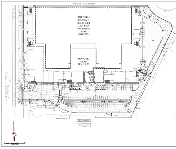
In long-term plans, in Spring 2026 PDX is finalizing the PDX2045 master plan update.

see 100% scale screenshot of map or original presentation PDF
Using Airport Codes on Social Media
When posting images or video about PDX on social media, use a hashtag for the airport code in your post. It can help people look for other posts on the topic of the airport.
For Portland Airport, the 4-letter ICAO code #KPDX is more precise and less likely to have acronym confusion. The 3-letter IATA code #PDX is fairly unique to Portland, but not always just referring to the airport. For other airports, such as the origin or destination of a flight you photograph at PDX, you may also want to include their ICAO and maybe IATA codes as hashtags. If you don't know the codes for other airports, Wikipedia has them.
A note about 4-letter ICAO codes for US airports: there are US-specific site you can use to look up US airports. There are a few traps to avoid. Every US airport has a FAA code, but not necessarily an ICAO or IATA code. The FAA code is all letters if the airport has IATA or ICAO codes. But at small airports, the FAA code contains numbers and then you also know is has no ICAO or IATA code.
Major airports in the Lower 48 states like PDX have the FAA code the same as the IATA code, and prepend a 'K' to the FAA code for the ICAO code. Alaska and Hawaii are in the Pacific region for ICAO codes so they start with 'P', specifically "PA" in Alaska and "PH" in Hawaii. US territories have their own regional allocations of ICAO codes. There are always exceptions. For example, the airport in Henderson, Nevada (Las Vegas area) is FAA code HND and ICAO KHND. But the IATA code HND was already taken by Tokyo Haneda Airport. So Henderson's IATA code is HSH, which is rarely used since it doesn't have airline service as a General Aviation reliever airport for Las Vegas McCarran International LAS/KLAS.
For some airports, they may be better known by their 3-letter IATA code than their 4-letter ICAO code, in cases where the IATA code is a more obvious abbreviation. In those cases, I recommend using both hashtags. For example, London Heathrow is LHR (IATA) / EGLL (ICAO). Amsterdam Schiphol is AMS (IATA) / EHAM (ICAO). Some don't seem to make much sense if you only know the name of the city. For example, Paris Airport is CDG (IATA) / LFPG (ICAO) is named for former French president Charles de Gaulle.
Online resources
- PDX info for the public
- official web site by Port of Portland
- PDX article on Wikipedia
- NWS weather PDX - weather observations and forecast
- PDX real-time air traffic status - FAA Air Traffic Control System Command Center
- PDX Portland Intl Airport - FlightAware
- Portland International Airport (PDX) traveler info from Travel Portland
- Portland International Airport (PDX) traveler info from Travel Oregon
- KPDX info for pilots
- AirNav - for pilots
- KPDX - PORTLAND INTL - digital ATIS (automated terminal information system) transcript
- KPDX METAR/TAF - aviation weather from NWS
- METAR: Meteorological Aerodrome Report, current weather observations
- TAF: Terminal Aerodrome/Area Forecast, 24-hour detailed forecast (larger airports only)
- AirNav airport info for PDX
- SkyVector aeronautical map at PDX
- PDX future plans
- PDX Next - information about airport improvement and construction projects
- PDX 2045: Planning the future of PDX - PDX long-term planning info by Port of Portland
- AvGeek stuff on Mastodon social media
- My @ikluft@avgeek.social account
- my thread on comings and goings from the Boeing Portland Paint Hangar
- Portland-related hashtags
- avgeek.social Mastodon instance (server)